Once away from Chandler it got rougher as we headed out into the open sea. When we got up in the morning the sky was grey and sea choppy and we were just off Entry Island with other parts of the Magdalens barely visible in the distance. We did circles off-shore before finally entering the harbour at Cap-aux-Meules. Two cute little tugs helped us dock, and the seamen spent forever tieing up. They obviously took the weather very seriously; the wind was strong and blowing on-shore.

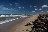
Once we were finally allowed off we found our B&B and then went exploring the closer parts of the islands.

5D3 2933  Taken at Latitude/Longitude:47.343933/-61.781919.  km       (Map link) 5D3 2948  Taken at Latitude/Longitude:47.362295/-61.844182.  km       (Map link) 5D3 2951  Taken at Latitude/Longitude:47.378341/-61.853795.  km       (Map link) 5D3 2955 5D3 2956
5D3 2958 5D3 2961  Taken at Latitude/Longitude:47.378575/-61.856408.  km       (Map link) 5D3 2963  Taken at Latitude/Longitude:47.378575/-61.856408.  km       (Map link) 5D3 2965  Taken at Latitude/Longitude:47.372462/-61.958778.  km       (Map link) 5D3 2966  Taken at Latitude/Longitude:47.398654/-61.937708.  km       (Map link)
5D3 2967  Taken at Latitude/Longitude:47.398654/-61.937708.  km       (Map link) 5D3 2968  Taken at Latitude/Longitude:47.398654/-61.937708.  km       (Map link) 5D3 2969  Taken at Latitude/Longitude:47.398656/-61.937690.  km       (Map link) 5D3 2970  Taken at Latitude/Longitude:47.398656/-61.937690.  km       (Map link) 5D3 2973  Taken at Latitude/Longitude:47.398656/-61.937690.  km       (Map link)
5D3 2977  Taken at Latitude/Longitude:47.398656/-61.937690.  km       (Map link) 5D3 2978  Taken at Latitude/Longitude:47.398656/-61.937690.  km       (Map link) 5D3 2979 5D3 2980  Taken at Latitude/Longitude:47.401014/-61.826983.  km       (Map link) 5D3 2981  Taken at Latitude/Longitude:47.401014/-61.826983.  km       (Map link)